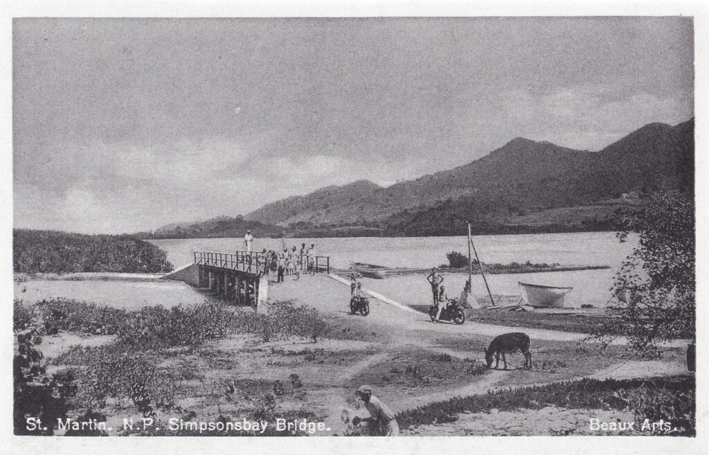

Though the bridge might seem small compared to its much younger sister, the Simpson Bay Lagoon Causeway Bridge, it has played a far more important role in St. Maarten’s history. Until the bridge (and the road to Philipsburg along Harold Jack) was built, from 1819 to 1933 the old fishing village of Simpson Bay was connected to the rest of Dutch-side St. Maarten only by sea. The natural sea gap was initially located in the Kim Sha Beach area. A wooden bridge was built there in 1933, followed by a stone one in 1950. As the natural stream had almost dried up by then, this bridge was almost obsolete as soon as it was completed.
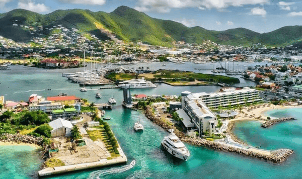
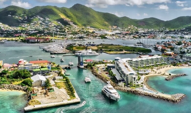
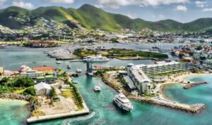
A new canal was later dug where the bridge now stands. Sand from this project was used to create Snoopy Island, now home to the IGY Marina and harbor. A bridge spanning the canal was built in 1970 and named after Captain John Sainsborough Lejuez, an Anguillian who married into the St. Maarten Vlaun family in the late 19th century.
With only a few meters of clearance, the passage permitted only limited ship sizes and soon became an obstacle for the growing nautical industry in the lagoon. In 1989, the canal was widened and the bridge was replaced with its current design. With the evolution of superyachts and megayachts docking in St. Maarten, even the current opening has proven to be limited in size. A well-known incident in 2019 involved the megayacht Ecstasea colliding with the bridge. Footage of the collision, thankfully without casualties, went viral on social media. To accommodate the ever-expanding size of superyachts and megayachts, new marinas have been built in Philipsburg, while the Simpson Bay area remains one of the Caribbean’s leading yachting hubs. The 1989 bridge has retained the official Lejuez name of its predecessor.
The old fishing history of Simpson Bay village is still remembered close to the bridge at the Simpson Bay Fish Market and its statue of a fisherman on it.
The adjacent St Maarten Yacht Club (freely accessible for non-members too) offers a great view of yachts and sailing ships coming in when the bridge opens. Ships pass by the yacht club balcony within a distance of some meters only. The often large amounts of megayachts and catamarans awaiting the opening times on either side of the bridge are a spectacle by itself.
Its yearly moment of global fame is during the Heineken Regatta in early March, when during extra opening times many of its hundreds of ships go back and forth along the regatta headquarters at the St Maarten Yacht Club.
The Simpson Bay Bridge opens at
• 8.30am (Boats going out)
• 9.30am (Boats coming in)
• 10.30am (Boats going out)
• 11.30am (Boats coming in)
• 3pm (Boats coming in)
• 4pm (Boats going out)
The VHF frequency is 12. Bridge authorities can be contacted via +1-721 545-5230 / 545-3183. The average height of the Simpson Bay Bridge is 2.4 meters, but can vary depending on tides. The channel is 17 meters wide and the controlling depth 6 meters.
For more nautical information pertaining to the bridges in the lagoon, please see our dedicated yachting page.
In need of more St Maarten / St Martin yachting information?
The St Maarten Marine Trades Association can be contacted for all your questions on chandlery, supplies and crew information. In both Simpson Bay and Philipsburg.
Find the location of the Simpson Bay Bridge on the map below!
The Simpson Bay Bridge is in the Pelican taxi zone. See our overview of St. Maarten taxi rates what pricing is in place from this location to your place of departure.
Instead of a taxi, the bus offers an easy option. The Simpson Bay Bridge is right on the Philipsburg–Maho line, with frequent service.
Back to Monuments Menu of Visit St Maarten / St Martin
Back to Main Page of Visit St Maarten / St Martin